ArcLeads
Sea-Ice Wintertime Lead Frequencies and Regional Characteristics in the Arctic,
NOV-APR 2003 - 2020
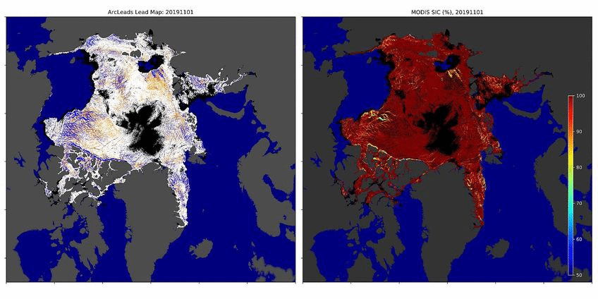
The presence of sea-ice leads represents a key feature of the Arctic sea ice cover. Leads promote the flux of sensible and latent heat from the ocean to the cold winter atmosphere and are thereby crucial for air-sea-ice-ocean interactions. We here apply a binary segmentation procedure to identify leads from MODIS thermal infrared imagery on a daily time scale. The method separates identified leads into two uncertainty categories, with the high uncertainty being attributed to artifacts that arise from warm signatures of unrecognized clouds. Each lead pixel is assigned a retrieval uncertainty for its own. Based on the obtained lead detections, we compute quasi-daily pan-Arctic lead maps for the months of November to April, 2002/03 - 2019/20 and associated sea-ice concentration maps. Our results highlight the marginal ice zone in the Fram Strait and Barents Sea as the primary region for lead activity. The spatial distribution of the average pan-Arctic lead frequencies reveals, moreover, distinct patterns of predominant fracture zones in the Beaufort Sea and along the shelf-breaks, mainly in the Siberian sector of the Arctic Ocean as well as the well-known polynya and fast-ice locations. Additionally, a substantial inter-annual variability of lead occurrences in the Arctic is indicated.
Articles:
Reiser, F., Willmes, S. and G. Heinemann, 2020: A New Algorithm for Daily Sea Ice Lead Identification in the Arctic and Antarctic Winter from Thermal-Infrared Satellite Imagery.
Remote Sensing, Special Issue Polar Sea Ice: Detection, Monitoring and Modeling, 12(12), 1957. DOI: 10.3390/rs12121957
Willmes, S. and G. Heinemann, 2015: Pan-Arctic lead detection from MODIS thermal infrared imagery.
Annals of Glaciology, 56(69):29-37. DOI: 10.3189/2015AoG69A615
Willmes, S. and G. Heinemann, 2016: Sea-Ice Wintertime Lead Frequencies and Regional Characteristics in the Arctic, 2003 - 2015.
Remote Sensing, 8(1), 4; DOI: 10.3390/rs8010004
Take a look into the data here:
We can provide daily data as a subset of the full data set (NOV-APR, 2002/03-2019/20) upon request.
The full data set will be released with another publication, following 2021.
Contact:
Dr. Sascha Willmes
E-mail: willmes[at]uni-trier.de
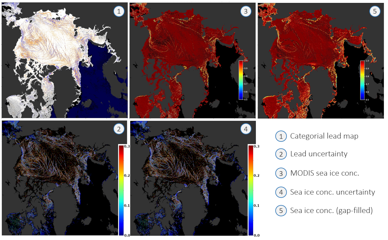
Each data file (daily netcdf) comes with 5 data fields:
1) A categorial lead map including lead class (Figure: blue), artefacts (organge), sea ice, clouds, open water, land mask.
2) Pixel-based lead detection uncertainty
3) 1 km sea-ice concentration
4) Combined lead and SIC uncertainty
5) a 3-day gap-filled SIC map (linear interpolation)
 ![]()
Animated GIF of daily lead maps for 1 NOV 2019 to 30 April 2020....
|